The Real Reason Your Flight Vanishes From Tracking Apps Mid-Journey
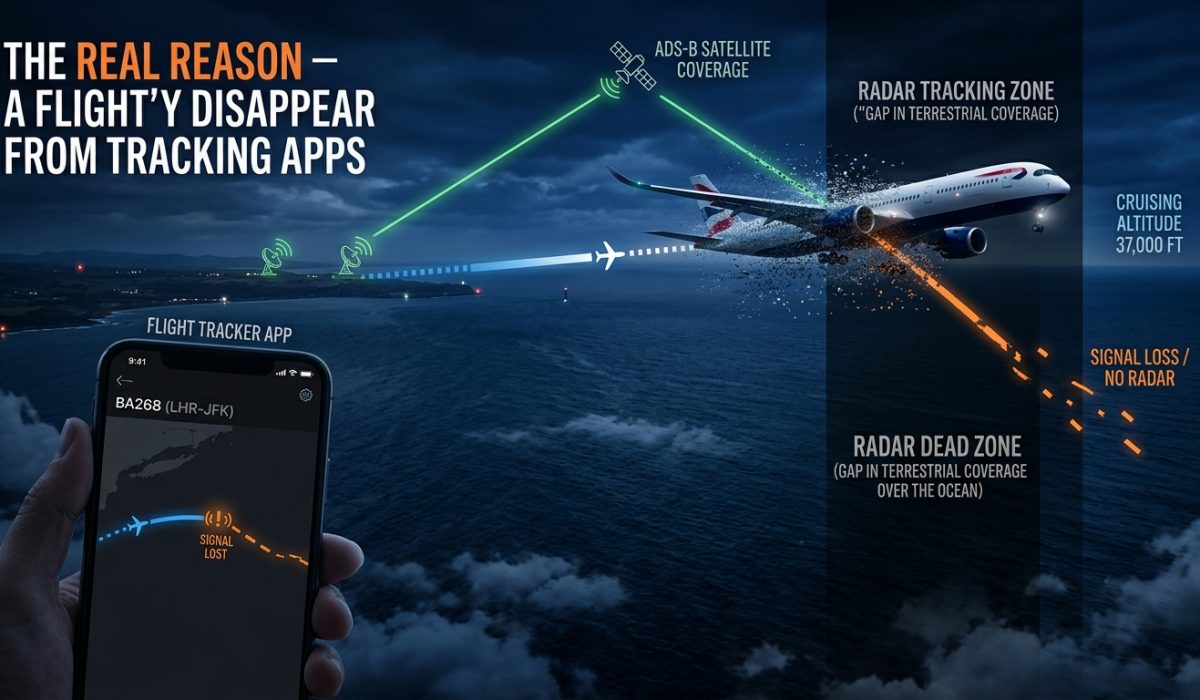
The Real Reason Your Flight Vanishes From Tracking Apps Mid-Journey
You open the flight tracker for the third time in an hour. The little plane icon was cruising somewhere over the western Atlantic, and now it has simply stopped. No update. No movement. Just a frozen timestamp and a map full of blue. You refresh again. Still nothing.
That moment of quiet dread is one of the most common travel experiences nobody talks about. Millions of passengers and anxious families live it every day. The good news is that the disappearance almost never means anything is wrong with the plane. It means the tracking system has hit a wall. Understanding that wall turns a nerve-wracking silence into something you can actually make sense of before your next trip.
Before You Fly: What Every Traveler Should Know
- Most consumer flight tracking relies on ground-based receivers that have no reach over open ocean.
- Aircraft keep broadcasting their ADS-B signal over water, but there are no receivers close enough to pick it up.
- Oceanic routes across the Atlantic and Pacific almost always drop off commercial tracking mid-flight.
- Air traffic control uses separate systems and always knows where the plane is, regardless of what any app shows.
- Some flights vanish not from coverage gaps but from deliberate government or airline tracking restrictions.
How a Flight Tracker Knows Where Your Plane Is
Before understanding why tracking fails, it helps to understand how it works in the first place. Modern commercial aircraft broadcast their position constantly using a system called ADS-B, which stands for Automatic Dependent Surveillance-Broadcast. The plane’s onboard equipment calculates its own GPS position and broadcasts that data as a radio signal roughly once per second.
That signal goes out in all directions. On the ground, a vast network of receivers picks it up. These receivers are operated by aviation authorities, private companies, and in some cases volunteers who have set up their own ADS-B antennas at home. Once a ground receiver catches the signal, it sends the data to aggregators. Those are the companies that power apps like FlightAware and Flightradar24. The aggregators clean up the data, combine feeds from multiple receivers, and push the result to your screen in near real time.
The whole process from broadcast to screen takes roughly 30 to 60 seconds in most cases. It feels live, and for practical purposes it is. But it only works because a ground receiver was close enough to hear the plane’s broadcast. That is where things start to break down.
The Ground Receiver Problem Over Open Water
Ground receivers can only hear what they can physically reach. A typical ADS-B receiver has a range of roughly 200 to 400 kilometers depending on terrain and altitude. That sounds like a lot. Over land, where receivers are clustered around airports, cities, and rural volunteer setups, it is usually enough to maintain continuous coverage.
Try placing a receiver in the middle of the North Atlantic Ocean, though. There is no land there. There are no towers. There is nothing to attach a receiver to. The result is a coverage gap stretching for thousands of kilometers, and any plane flying through it has no ground station within range to hear its broadcasts.
The same problem exists over the Pacific, large parts of Central Africa, the polar regions, and stretches of Central Asia. These are not rare routes. Flights between North America and Europe cross the Atlantic gap on every single trip. Flights between North America and Asia cross the Pacific gap. Between them, these two corridors carry hundreds of millions of passengers every year, and every single one of those passengers temporarily disappears from commercial tracking.
Oceanic Routes: Where the Map Goes Dark
A transatlantic flight typically leaves ADS-B coverage somewhere west of Ireland or off the coast of Newfoundland. Once it crosses that invisible line, your tracking app has no new data to work with. Some apps will draw an estimated flight path across the gap using flight plan data filed before departure. Others simply freeze the icon at the last known position. Neither approach tells you where the plane actually is in real time.
This is the part of the journey where passengers and their families sometimes spiral into unnecessary worry. The plane has not dropped off the face of the earth. It is cruising along exactly as planned, at altitude, on schedule. The app just cannot see it anymore. For anyone who wants to understand the full technical picture of why flights disappear from tracking networks, the explanation covers the mechanics without requiring an aviation background to follow.
The Atlantic reappearance usually happens around the coast of Ireland or Scotland on eastbound flights, or off Newfoundland on westbound ones. The icon snaps back into place and continues its journey as if nothing happened, which from the plane’s perspective is exactly what occurred.
Satellite Tracking: The Partial Fix That Is Still Rolling Out
A solution does exist for the oceanic gap, and it is slowly becoming more available. Satellite-based ADS-B can receive the same broadcasts that ground stations collect, but from orbit. A company called Aireon launched a space-based ADS-B network using the Iridium satellite constellation, and it has dramatically improved oceanic position awareness for air traffic controllers.
North Atlantic air traffic control now has far better real-time visibility than it did a decade ago, which has allowed aircraft to fly closer together and use more fuel-efficient routes. Standardized aircraft equipage requirements, including the ADS-B performance mandates for U.S. airspace, have pushed adoption across commercial aviation and made satellite-based reception far more practical at scale.
The catch is that consumer tracking apps do not always have access to the same satellite data that air traffic controllers use. The Aireon data is available to aviation authorities and airlines. Apps have to license it separately, and many have not yet fully integrated oceanic coverage. That gap between what ATC can see and what your phone can see is part of why the freeze still happens even as the underlying technology continues to improve.
Restricted Airspace and Intentional Blackouts
Coverage gaps are not the only reason a flight disappears from your screen. Some flights drop off tracking deliberately. Governments can request that military and government aircraft be blocked from public tracking, and commercial flights operating in or near certain airspace can also face restrictions.
Several countries have historically limited or blocked the sharing of ADS-B data within their airspace. Certain military exercise zones produce gaps. Some airlines choose to opt out of public tracking on specific routes, either for security reasons or at the request of passengers who value privacy. A flight that an airline has opted out of public tracking may show up as “blocked” in some apps, or may not appear at all.
The result is a patchwork of tracking coverage that varies by country, airline, route, and aircraft equipment level. A flight might be perfectly visible for the first three hours of a journey and then vanish as it crosses into a restricted zone, even if it is flying over land the entire time. This catches people off guard precisely because the disappearance feels different from the oceanic gap everyone has come to expect.
How Tracking Data Travels From the Plane to Your Screen
The path from aircraft to your app involves more steps than most people realize. Here is the sequence for a standard flight with good ground coverage:
- The aircraft’s GPS receiver calculates its precise position several times per second.
- The ADS-B transponder encodes that position along with altitude, speed, and a unique aircraft identifier, then broadcasts it as a 1090 MHz radio signal.
- One or more ground receivers within range pick up the signal and timestamp it upon arrival.
- Each receiver sends the raw data packet over the internet to a data aggregator.
- The aggregator cross-checks position reports from multiple receivers to remove errors and produce the most accurate position calculation.
- The clean data is pushed via API to third-party apps, which render it as a moving icon on a map.
- Your phone downloads the update and repositions the flight marker on your screen.
Every step in that chain requires a functioning receiver within radio range of the plane. Remove that receiver and the whole chain stops at step three. The plane keeps broadcasting. The signal keeps traveling outward. It just has nowhere to land.
Air Traffic Control Always Has Eyes on Your Flight
Here is what matters most when the app freezes: professional air traffic controllers are never in the dark the way consumer apps are. Over ocean routes where ADS-B coverage is thin, pilots use structured position reporting procedures to stay in contact with oceanic control centers. Controllers assign position checks at regular waypoints, and pilots call in their actual position, altitude, and speed as they cross each one.
Newer aircraft also use systems like CPDLC, which stands for Controller-Pilot Data Link Communications, and ACARS, the Aircraft Communications Addressing and Reporting System. These digital channels allow precise position data and two-way messages between the cockpit and control centers even in the complete absence of radar or ADS-B coverage. The plane knows where it is. The airline knows where it is. Air traffic control knows where it is. The app on your phone is simply the one entity out of the loop.
Oceanic crossings are among the most carefully managed portions of any long-haul flight. The procedural discipline required for non-radar airspace is rigorous, and pilots flying these routes are specifically trained for it. The silence in the app is not a reflection of the safety standards being applied at altitude. It is a reflection of an infrastructure gap that consumer technology has not yet fully bridged.
When the Frozen Icon Stops Being Something to Fear
Flight tracking apps are remarkable tools. They have made aviation more transparent than it has ever been, and they genuinely help travelers stay informed about delays, gate changes, and arrival estimates. But they are built on technology with physical limits, and those limits show up most reliably on the very routes where anxious travelers most want to watch the progress.
The next time a flight icon freezes somewhere over an empty blue ocean, treat it as a geographic fact rather than a warning. The plane is in that blue somewhere, being watched by professionals using tools far more robust than anything available on a smartphone. It will reappear on the coastline of whatever continent it is heading toward, right on schedule, carrying passengers who spent the crossing completely unaware their icon had gone quiet.
The silence in the app is not a signal. It is a gap in the infrastructure, and those gaps get smaller with every passing year.